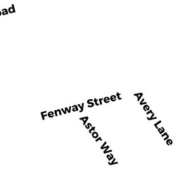
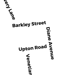
12 AVERY LN
Owner Information
SPEVACK THEODORE A TR
12 AVERY LN
SOUTH YARMOUTH, MA 02664


Property Details
12 AVERY LN is classified as a Single Family Residential (Ranch).
The primary structure on this property was built in 1972. There are 4,006ft2 of built area within this property. There is 1,692ft2 of residential/living space within this property.
12 AVERY LN is valued at $458,600. The land is valued at $122,100 and the structures are valued at $334,500. There is an additional valuation of $2,000 on this property.
The most recent deed for 12 AVERY LN is recorded at the local registrar in Book D1220610, Page 0. 12 AVERY LN was last sold on Tuesday, May 7, 2013 for $100.
Assessment data from fiscal year 2022.
Flood Data
According to the FEMA National Flood Hazard Layer, this property does not appear to be in a flood zone. It may also be in an area not yet reviewed. Nonetheless, confirm this information prior to taking any action.
To view the flood hazards around this property, create a FEMA "Firmette" Map of the area around 12 AVERY LN.
Broadband Internet Providers
| Provider | Type | Bandwidth (mbps) | |
|---|---|---|---|
| HughesNet | Satellite | 25 | 3 |
| VSAT Systems, LLC. | Satellite | 2 | 1 |
| Viasat Inc | Satellite | 35 | 3 |
| Verizon New England Inc. | DSL | 5 | 0 |
| Comcast | Cable | 1000 | 35 |
| T-Mobile | Fixed Wireless | 25 | 3 |
| GCI Communication Corp. | Satellite | 0 | 0 |
Broadband service provider data from December 2020.
Adjacent Properties
- 179 DIANE AVE
Single Family Residential owned by MACLELLAND JOHN R - 173 DIANE AVE
Single Family Residential owned by MACDONALD JOHN G - 169 DIANE AVE
Single Family Residential owned by ROMMEL WILLIAM F IV - 8 AVERY LN
Single Family Residential owned by AVERY DONALD L - 18 AVERY LN
Single Family Residential owned by WEBB JAMES D